
Unseasonably Hot Temperatures Sweep the East Coast in Mid-April 2026
As April unfolds, many states along the U.S. East Coast are experiencing a sudden surge of unusually high temperatures, with summer-like heat settling in weeks earlier than typical. This week, residents across major cities from New York to Richmond, Virginia, are seeing daytime highs soar into the 80s and 90s Fahrenheit (around 30 to mid-30s Celsius), a striking departure from the usual spring climate.
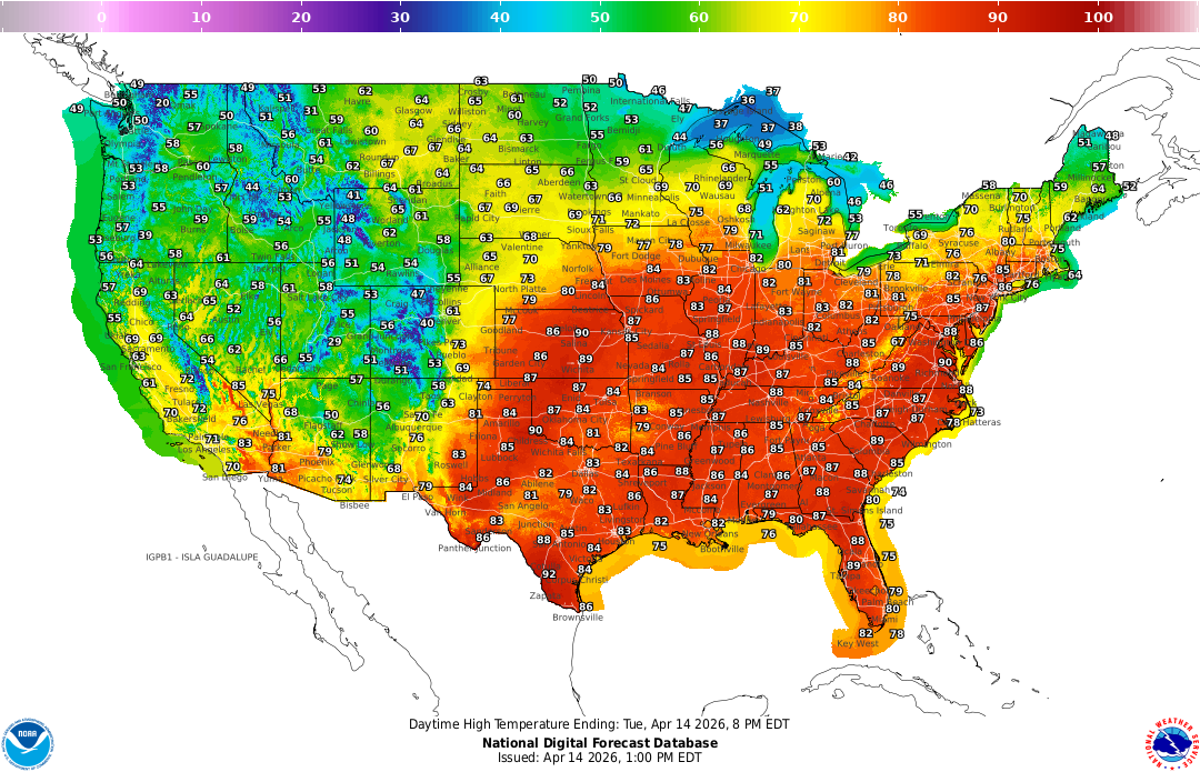
According to the National Weather Service (NWS), New York City could reach temperatures in the mid-80s Fahrenheit (approximately 30 degrees Celsius), while cities like Philadelphia and Washington, D.C., may see readings climb into the 90s Fahrenheit. Richmond, Virginia, is forecasted to hit 94 degrees Fahrenheit (34 degrees Celsius) by Wednesday, marking a notably warm day for mid-April.
Meteorologists attribute this spike in temperatures primarily to a persistent area of high pressure dominating the eastern United States. Maryland-based NWS meteorologist Frank Pereira explains that the high-pressure system is causing winds to flow from the southern regions, bringing warm air northward. Additionally, the lack of significant cloud cover allows the sun's rays to heat the surface more effectively. Typically, storm activity can help cool the air, but this week's minimal storm chances mean that little relief is available from the heat.
Wednesday is expected to be the hottest day of the week for much of the mid-Atlantic region. The NWS has issued heat-related warnings for areas of North Carolina, Virginia, New Jersey, and Pennsylvania, indicating a "moderate" risk of heat stress and other heat-related health concerns. Around Washington, D.C., some pockets are even categorized as facing a "major" risk, underscoring the severity of the rapid temperature rise.
"This is impressive heat for mid-April, arriving weeks earlier than we typically see in many cities," said Matt Benz, a senior meteorologist at AccuWeather. Benz pointed out that early-season heat tends to impact people more intensely because their routines, clothing choices, and outdoor plans are usually still adjusted to cooler spring temperatures rather than summer conditions.
For context, historical temperature data from the NWS shows that April temperatures in New York City's Central Park typically range in the 40s and 50s Fahrenheit (single digits to mid-teens Celsius). The highest recorded April temperature in Central Park was 96 degrees Fahrenheit (36 degrees Celsius), documented twice before-in 1976 and 2002. This year's early heat wave approaches these record highs, emphasizing its unusual nature.
The current heat wave follows a pattern of record-breaking warmth earlier in the year. March 2026 saw at least eight states record their highest temperatures ever for that month. Furthermore, nine western states experienced their hottest winters in 2025. These trends align with broader climate patterns, including the expected return of El Niño conditions this summer, which forecasters predict may elevate global temperatures even further.
While this week's heat wave is remarkable, meteorologists anticipate that cooler weather will arrive soon. Pereira notes that a "pretty strong" cold front is expected to move through the eastern U.S. over the coming weekend, bringing relief by lowering temperatures and ending the current streak of unseasonable heat.
This early surge of summer-like weather highlights the increasing variability and extremity in seasonal temperatures, a phenomenon scientists continue to monitor closely amid concerns about climate change. The abrupt transition to hot conditions challenges communities to adapt quickly, especially as heat-related health risks become more pronounced outside the usual summer months.
Jackie Flynn Mogensen, the reporter covering this story, is based in New York City and specializes in science reporting. She holds advanced degrees in environmental communication and earth sciences and has been recognized for excellence in science communication. Her work helps bring critical scientific developments and environmental trends to public attention.
In summary, the East Coast is currently enduring an intense and early heat wave driven by high pressure and southern winds, pushing temperatures well above normal for April. While this summer preview may feel sudden, it fits into a larger pattern of rising temperatures and extreme weather events linked to global climate trends. Fortunately, a cold front expected this weekend should provide some respite from the heat, allowing temperatures to return closer to typical spring levels. As communities face these changing weather patterns, awareness and preparedness for heat-related health risks remain essential.