
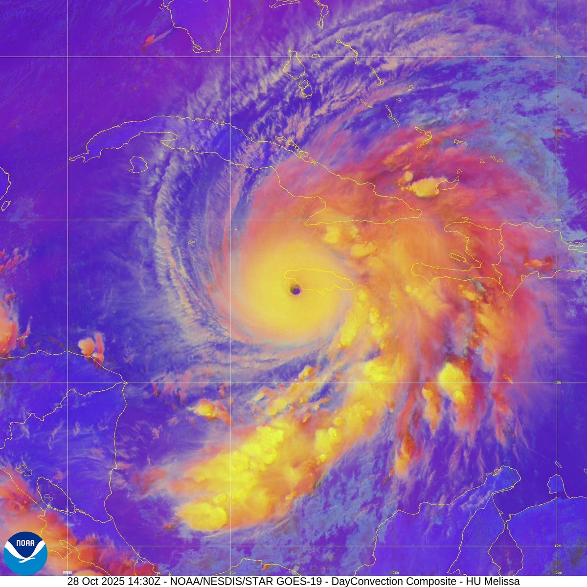
On October 28, 2025, Hurricane Melissa solidified its place among the most intense storms ever recorded in the Atlantic Ocean. Achieving Category 5 status, Melissa’s sustained winds reached an astonishing 185 miles per hour, with a central pressure measured at 892 millibars. This remarkable intensity places it in a tie with the infamous 1935 Labor Day hurricane as the third most powerful Atlantic hurricane on record. The 1935 storm is notorious for the devastation it wrought, particularly in the Florida Keys, underscoring the immense destructive potential of a storm like Melissa.
Experts emphasize that hurricanes of Melissa’s strength are exceptionally rare. Brian McNoldy, a hurricane researcher at the University of Miami, commented that storms of this magnitude represent the upper limits of hurricane intensity. Even in the western Pacific Ocean, where extremely powerful typhoons are more common, few tropical cyclones reach the intensity seen in Melissa. This raises questions about the unique atmospheric and oceanic conditions that allowed Melissa to reach such extraordinary strength.
The answer lies in a near-perfect alignment of meteorological factors that fueled Melissa’s rapid and sustained intensification. According to McNoldy, the hurricane is “taking advantage of every possible condition it can” at this moment. Atmospheric scientist Kim Wood from the University of Arizona described the situation as both scientifically understandable and astonishing to witness in reality. The combination of environmental elements driving Melissa’s power is rare and complex, illustrating the intricate dynamics behind hurricane development.
At the core of any tropical cyclone is convection, which is driven by the temperature contrast between warm ocean surfaces and the cold atmosphere high above the storm. This convection acts as the hurricane’s engine, cycling heat and moisture upward and out. The outflow occurs near the tropopause, the boundary between the troposphere—where weather occurs—and the overlying stratosphere. The height of the tropopause varies with latitude and region; it is higher in tropical areas than in temperate zones and higher over the Pacific Ocean compared to the Atlantic. This difference partly explains why Pacific typhoons tend to be stronger than Atlantic hurricanes, despite being similar phenomena.
Melissa has capitalized on this elevated tropopause and its extremely cold cloud tops to fuel exceptional convection. The storm’s upper-level environment is optimal for sustaining its strength, allowing it to maintain and even increase its intensity. Meanwhile, at the ocean surface, Melissa has remained nearly stationary over some of the warmest waters in the Atlantic basin. October is typically the peak period for Caribbean Sea surface temperatures, as the ocean accumulates heat during the summer months. Recent buoy data showed surface temperatures reaching 30 degrees Celsius (86 degrees Fahrenheit) or higher, extending down to depths of 60 meters (nearly 200 feet). This deep pool of warm water provided a vast reservoir of energy for Melissa to tap into.
Typically, slow-moving storms like Melissa, which has advanced at only 3 to 5 miles per hour, tend to churn up cooler waters from beneath the surface. This upwelling of cold water often weakens hurricanes by cutting off their heat supply. However, in Melissa’s case, the ocean’s warmth extends deep enough that the storm’s slow movement has not caused significant cooling. McNoldy describes the location as “pretty much the perfect place” for Melissa to sustain its power. If Melissa had been moving faster, it might not have been able to linger over the warm waters long enough to intensify as dramatically as it did. The storm’s slow progression, therefore, played a crucial role in maintaining its strength.
Melissa’s intensity was not only remarkable but also maintained for an unusually long duration. The hurricane has held Category 5 status for more than a day, a testament to the persistent favorable conditions. The storm underwent rapid intensification—a process in which wind speeds increase by at least 35 miles per hour within 24 hours—not just once but twice. Initially, Melissa’s winds surged by twice the threshold for rapid intensification, a truly extraordinary development. Later, even after achieving Category 4 strength, Melissa underwent another period of rapid intensification, further boosting its power.
As Melissa slowly approached Jamaica, it continued to defy expectations. Typically, hurricanes weaken as they near land due to friction and interaction with terrain. Jamaica’s hilly landscape would normally disrupt the storm’s structure and diminish its strength. Yet, McNoldy observed that “Melissa looks like it doesn’t even know Jamaica is there,” appearing completely und