
In an extraordinary meteorological milestone, the 2025 Atlantic hurricane season has witnessed the emergence of its third Category 5 hurricane, Hurricane Melissa, making it only the second recorded season to produce more than two storms of such devastating intensity. This remarkable occurrence places 2025 alongside the infamous 2005 season, which holds the record with four Category 5 hurricanes: Emily, Katrina, Rita, and Wilma.
Hurricanes are classified on the Saffir-Simpson scale, which measures storm intensity based on sustained wind speeds. A storm reaches Category 1 status at winds of 74 miles per hour, but it is the Category 5 storms—those with winds exceeding 157 miles per hour—that stand as the most powerful and potentially destructive. These storms are rare phenomena, requiring a precise combination of atmospheric conditions and oceanic energy to develop and maintain their ferocity. Since reliable records began in 1851, only 45 Atlantic hurricanes have achieved Category 5 status, underscoring how exceptional Melissa’s development has been.
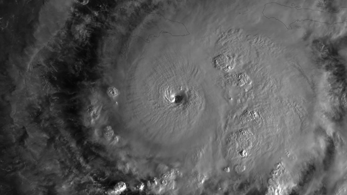
Hurricane Melissa, currently intensifying in the Caribbean Sea and approaching Jamaica, has demonstrated extreme rapid intensification, a process where a tropical cyclone’s wind speeds escalate dramatically over a short period. Remarkably, Melissa’s winds surged from a modest 70 miles per hour tropical storm last Saturday morning to a formidable Category 4 hurricane with winds of 140 miles per hour by Sunday. This doubling of wind speeds within such a brief window is twice the rate defined as the threshold for rapid intensification and stands among the fastest intensification rates ever recorded in the Atlantic basin. Meteorologist Michael Lowry noted that this level of strengthening “is on the fringes of what’s ever been observed,” highlighting the storm’s extraordinary nature.
By Tuesday morning, Melissa had reached a peak wind speed of 185 miles per hour and a central atmospheric pressure of 892 millibars, tying it for the third most intense hurricane on record in the Atlantic. Only six other storms have ever recorded pressures below 900 millibars, a key indicator of hurricane strength, and just five others have matched or exceeded Melissa’s wind speeds. The storm’s remarkable power is largely attributed to exceptionally warm sea surface temperatures in the Caribbean, which provide the immense energy that fuels such rapid and intense development.
The increasing frequency and intensity of hurricanes like Melissa are closely linked to the broader context of climate change. Rising ocean temperatures provide more accessible energy for storms, making rapid intensification events more common and boosting the likelihood that hurricanes will reach higher categories on the Saffir-Simpson scale. Scientific studies have shown that climate change has already amplified the wind speeds of every hurricane in recent years, including those in the 2024 season. Furthermore, research indicates that the proportion of tropical cyclones reaching Category 3 or higher has increased significantly over recent decades, signaling a troubling trend toward more frequent and powerful hurricanes.
Over the past decade alone, the Atlantic basin has experienced 13 Category 5 hurricanes, including seven in just the last three years. This uptick in the most severe storm categories underscores the growing risks that coastal communities face from increasingly intense tropical cyclones. As climate change continues to warm the planet and its oceans, meteorologists and climate scientists anticipate that such extreme storms will become even more common.
The 2025 season’s unprecedented number of Category 5 hurricanes, capped by the arrival of Hurricane Melissa, serves as a stark reminder of the evolving nature of extreme weather events in a warming world. It highlights the urgent need for enhanced preparedness and resilience measures in vulnerable regions, as well as the critical importance of climate action to mitigate future risks.
Melissa’s rapid intensification and extreme strength also provide valuable data for scientists seeking to understand the complex dynamics of hurricane formation and intensification. Observations from satellites such as NOAA’s GOES-19, which captured detailed imagery of Melissa swirling in the Caribbean Sea, contribute to improved forecasting models and early warning systems that can save lives and reduce property damage.
This extraordinary hurricane season, marked by the emergence of multiple Category 5 storms, not only challenges our historical understanding of Atlantic hurricanes but also underscores the profound impacts of climate change on severe weather patterns. It calls for continued scientific research, thoughtful policy responses, and community engagement to address the multifaceted challenges posed by these powerful natural disasters.
Andrea Thompson, a senior editor with extensive experience covering environmental and earth science topics, reported on these developments. Her expertise and years of dedicated science journalism bring critical insights into the