
The Middle East’s abundance of oil and natural gas—and the geopolitical complexities surrounding its export—can be traced back to an ancient geological event: the collision of tectonic plates that shaped the region’s landscape millions of years ago. This phenomenon not only created vast hydrocarbon deposits but also explains why these resources are funneled through a narrow and vulnerable passage known today as the Strait of Hormuz.
The Strait of Hormuz is a critical maritime chokepoint located at the mouth of the Persian Gulf, a narrow waterway connecting the Gulf to the Gulf of Oman and the Arabian Sea. Typically, about one fifth of the world’s oil and liquefied natural gas (LNG) exports pass through this strait, making it an indispensable artery for global energy supplies. However, the strait’s narrowness and strategic location have made it a focal point of geopolitical tension. For instance, in late February 2026, following attacks by the U.S. and Israel on Iran, the Strait of Hormuz was effectively closed, causing a sharp spike in global oil and gas prices and raising fears of an impending energy crisis.
While this situation is often viewed through a political lens, the underlying reasons for the strait’s strategic significance lie deep within the Earth’s geological history. The Middle East’s oil wealth and the formation of the Persian Gulf itself both stem from the slow-motion collision of two massive tectonic plates: the Arabian plate, which carries Saudi Arabia and the Persian Gulf, and the Eurasian plate, which includes much of Asia and Europe.
This continental collision has been ongoing for tens of millions of years and has dramatically shaped the region. As the Arabian plate pushed northeastward into the Eurasian plate, it caused the Earth’s crust in the collision zone to crumple and fold, giving rise to the Zagros Mountains in Iran—a long mountain range stretching approximately 1,600 kilometers from eastern Turkey to the Strait of Hormuz. These mountains are not only a striking geological feature but also a key to understanding why so much oil is trapped beneath the surface nearby.
The collision forced the crust to bend and flex, creating a geological depression known as a foreland basin adjacent to the mountains. This basin, called the Persian Gulf Basin, is an area where sediments and organic materials accumulated over hundreds of millions of years. These sediments include layers of organic-rich shale, sandstone, and limestone, which over time and under immense pressure and heat, transformed into oil and natural gas. The sandstone and limestone layers, fractured and porous, provided the perfect reservoirs to trap these hydrocarbons, while overlying layers of hard caprock sealed them underground.
The process that created these hydrocarbon-rich layers began long before the plates collided. Hundreds of millions of years ago, the northern edge of the Arabian plate was a passive margin—essentially a quiet boundary between continental and oceanic crust that allowed sediments to accumulate undisturbed. Similar to the modern-day eastern coast of the United States, this region experienced cycles of rising and falling sea levels, leading to the buildup of thick sedimentary layers rich in organic material.
When the Arabian plate began its northeastward journey about 30 million years ago—driven in part by the opening of the Red Sea on its southwestern edge—it started to ram into the Eurasian plate. This collision compressed and folded the sediment layers into complex structures, forming the Zagros fold-and-thrust belt. This belt is considered a geologist’s dream because it beautifully exposes the processes involved in mountain building and hydrocarbon trapping.
The Zagros Mountains themselves are highly deformed and generally too fractured to hold large accumulations of oil and gas. However, nearby regions with less intense deformation contain enormous hydrocarbon fields trapped within the folds of the rocks. The combination of organic-rich source rocks, porous reservoirs, and impermeable caprocks, all folded and faulted by tectonic forces, created some of the world’s richest oil and gas deposits. It is estimated that this region contains about 12 percent of the global oil reserves.
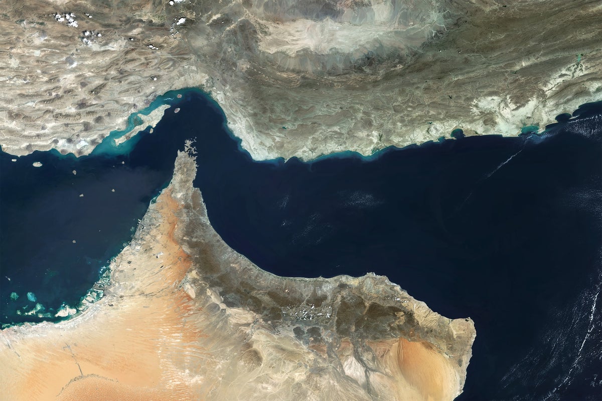
The Persian Gulf Basin, formed by the downward flexing of the crust under the weight of the Zagros Mountains, is relatively shallow—only about 110 meters deep and up to 340 kilometers wide. Its narrowest point is at the Strait of Hormuz, where the gulf is squeezed down to about 55 kilometers in width. This narrowing is due in part to the presence of the Musandam Peninsula, which juts out into the water and is composed